Entry No. 37 — the Fort Collins file — filed under: wwii-history
Crown Point B-17 Crash Site
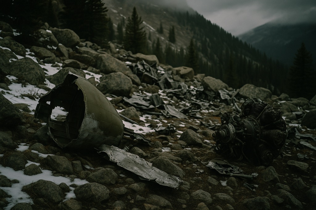
On June 13, 1944, a fully crewed Army Air Forces B-17 slammed into a snow-covered mountainside north of Crown Point and killed four of its ten men — pilot Drury Holt among them — in a place locals still call Hell's Half Acre. Nearly 80 years later the wreckage is still there: shredded fuselage panels, mangled engine components, and bomber fragments scattered across a boulder field at around 11,000 feet. Green metal tags nailed to trees are the only navigation aid on the final approach, which the trail guides charitably describe as a treasure hunt. Six men walked away from this; standing in the debris field, that fact is somehow the most unsettling part.
The move: Drive Pingree Park Road to the Stormy Peaks Trailhead, hike roughly 3 miles through Roosevelt National Forest following the green tree tags, and spend time in the boulder-strewn debris field before heading back.
📍 Before you go Trailhead is at the end of Pingree Park Road (Stormy Peaks Trailhead, approx. 40.5705, -105.5885). Trail is ~9 km round-trip with ~370 m elevation gain; terrain is forested with a primitive, poorly-signed final approach — bring GPS. Recommended window is May through October; road and trail can be snow-covered outside that window. No permit required; dogs on leash allowed.
- 📍 Bellvue
- 💸 Free
- ⚡ Up for anything
- 🌗 Outdoors
Hours: Added 2026-06-21 — confirm current hours before you go.
⚠ Seasonal or scheduled — always check before you go.
Plan a visit & invite your people →
Proof: source 1 · source 2 · source 3
last checked: 2026-06-21