Entry No. 21 — the Lawton & Fort Sill file — filed under: miscellanea
Parallel Forest
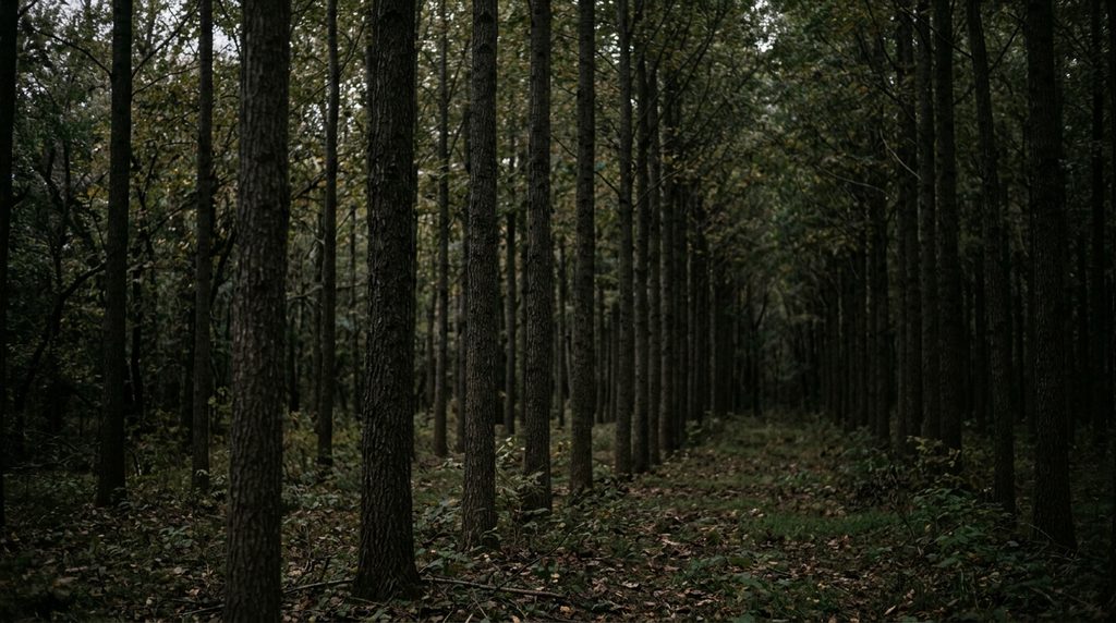
Dense, evenly spaced rows of trees were planted to grow straight, knot-free fence posts. The unusual planting has accumulated stories of disappearing children and shadows moving through the trees after dark.
→ Three more haunted places & dark-history spots in Lawton & Fort Sill — never the same twice
The story
In 1912, when the Wichita Mountains were still managed as a national forest reserve, refuge supervisor Frank Rush oversaw a forestry experiment that went aggressively against nature. Across roughly sixteen acres near Cedar Creek, federal workers used the deep-hole method to plant more than 20,000 eastern red cedar wildlings. Instead of allowing them to scatter naturally, they set each sapling into a rigid Euclidean grid, precisely six feet apart from its neighbors in every direction. The logic was strictly utilitarian: pack the trees tightly enough to starve the lower limbs of light, forcing the trunks to shoot straight upward into knot-free timber destined for fence posts.
The harvest never happened, but the geometry took hold. Over the following century, the cedar crowns knitted together into a light-suffocating ceiling that choked out the undergrowth, leaving behind bare dirt and hundreds of unnervingly straight corridors where your sightline never breaks. Near the creek bank at the edge of the grid sits a low, circular ring of stacked granite fieldstones—dubbed the 'stone altar' by generations of Southwestern Oklahoma teenagers. That combination of unyielding mathematical order and an unexplained stone circle spawned decades of campfire lore: vanished wanderers, spectral figures pacing the tree corridors, and midnight ritualists slipping through the trunks.
What it's like
Arriving here feels less like a hike and more like stepping onto an analog test pattern. Turn off Meers Road onto the unmarked gravel pull-out, slip through the gate, and the scrubby granite plains abruptly give way to dead-straight cedar corridors that mess with your depth perception. An informal 0.8-mile trail loops through the sixteen acres, but because every single trunk looks identical and the canopy blocks out the sky, your internal compass stops working almost immediately; keep your offline map open if you want to find the stone ring near Cedar Creek without pacing in repetitive circles. Cell service is virtually nonexistent, and while refuge hiking trails officially close at sunset, the interior turns murky long before dusk. Go on an overcast weekday afternoon when the wind hums through the needles and you won't have to share the grid with teenage ghost hunters.
The move: Follow the dirt loop beneath the dark cedar canopy, then stop together and see how many dead-straight aisles you can spot between trunks planted six feet apart.
- 📍 Wichita Mountains near Lawton and Fort Sill, OK
- 💸 $$
- ⚡ Up for anything
- 🌗 Indoors
Where: Wichita Mountains Wildlife Refuge, 21088 State Hwy 115, Cache, OK 73527 (Parallel Forest is a named stand within the refuge; it has no separate street address)
Hours: Added 2026-11-18 — confirm current hours before you go.
Pair it with
- The Holy City of the Wichita Mountains — Less than a mile south, trade the government's rigid cedar grid for a surreal 66-acre granite replica of biblical Jerusalem hand-built by the CCC during the Depression.
- Meers Store & Restaurant & Fault Seismograph — Head two miles north to decompress inside a surviving 1901 gold-camp store that dishes out seven-inch burgers over an active seismic fault line.
- Mount Scott Summit Spiral Road — Shake off the forest's claustrophobic tree lines by corkscrewing three miles up a spiraling granite roadway for an unobstructed look across the entire refuge.
More weird in Lawton & Fort Sill

Good to know
Where is Parallel Forest located?
It sits inside Wichita Mountains Wildlife Refuge along Meers Road (State Highway 115), just north of the Cache Meers Road intersection. There are no signs for it—look for a small gravel-and-dirt pull-out on the west side of the highway.
What is the circular stone altar near the creek?
At the edge of the cedar grid near Cedar Creek is a low circular ring of native stones. While local folklore insists it was built for occult rituals, it is an undocumented stone fire ring or campsite foundation that has gathered decades of regional myth.
How long is the trail and what is the terrain like?
The informal loop trail runs about 0.7 to 0.8 miles. The terrain is flat, but the ground is heavily webbed with exposed surface roots and slippery cedar needles, with numerous unmarked herd paths branching off in all directions.
Is there an entrance fee or permit needed?
No. Access to Wichita Mountains Wildlife Refuge and the Parallel Forest pull-out is completely free; no day-use permits are required.
What are the hours?
Refuge hiking trails and pull-outs close at sundown, though through-traffic is permitted on state highways 24 hours a day.
Plan a visit & invite your people →
Further reading: z94.com · tucollegian.org · Thrillist · Atlas Obscura · travelok.com
last checked: 2026-11-18