Entry No. 25 — the Watertown & Fort Drum file — filed under: miscellanea
Sheepfold Cemetery
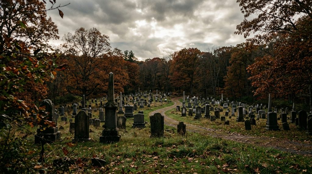
A mysterious historic burial ground on the base whose exact origins remain unknown to history, though it is believed to have originated as a private plot for the LeRay family.
→ Three more haunted places & dark-history spots in Watertown & Fort Drum — never the same twice
The story
When the federal government swallowed over 100,000 acres of Jefferson County farmland in 1941 to expand Pine Camp into what became Fort Drum, dozens of rural communities and thirteen historic burial grounds were abruptly trapped behind the perimeter fence. Most of those graveyards now sit stranded deep inside live-fire training areas, locked away from the public except for a brief five-hour window on Memorial Day. Sheepfold Cemetery—recorded in 19th-century county records as Pine Plains or LeRaysville Cemetery—is the anomaly. It sits right along Route 26 near the Oneida/Gas Alley Gate, fully visible and stubbornly accessible from the shoulder of the public road.
The name is literal: in the early 1800s, French aristocrat and land speculator James LeRay de Chaumont built a grand manor nearby and kept his livestock penned on these sandy flats. Rumors long insisted the walled plot was intended as a private dynastic resting ground for the LeRay family, but county death records paint a different picture: no LeRay heirs were ever buried here. The only person interred with ties to the household was Rachel, an African American nursemaid employed by the estate. Instead, the plot gradually filled with nearly 300 graves belonging to early frontier millers, blacksmiths, and farming families from the vanished hamlet of LeRaysville.
The real oddity lies right against Sheepfold's property line. In 1944, the U.S. Army established the Pine Camp Prisoner of War Cemetery directly adjacent to the civilian plots. That tiny, immaculate enclosure holds the remains of seven Axis soldiers—six German and one Italian—who died while interned at the camp before the war ended. Standing along the fence line, you are looking at an accidental side-by-side collision of two centuries: tilted 19th-century upstate pioneer headstones on one side, and the stark markers of foreign conscripts who died thousands of miles from home on the other.
What it's like
Visiting Sheepfold feels less like touring a municipal park and more like pulling over at an accidental seam between civilian history and an active military reservation. You park along the unpaved grass shoulder of Route 26 (Great Bend Road) just outside the installation's gate checkpoint. There are no visitor kiosks, docents, or manicured walkways—just an open expanse of weathered slate and marble markers set against the Pine Plains brush, frequently punctuated by the distant thud of range artillery or rotary blades from the nearby airfield. Ground can be soggy and footing is rough, so skip thin-soled shoes and stick strictly to daylight hours.
The move: Pull onto the grassy shoulder of Route 26 outside the base gate to explore the weathered slate and marble headstones stranded on these former sandy livestock flats.
- 📍 Fort Drum
- 💸 $$
- ⚡ Up for anything
- 🌗 Indoors
Where: Route 26 (Great Bend Road), between Evans Mills and Oneida/Gas Alley Gate, Fort Drum, NY 13602
Hours: Added 2026-11-18 — confirm current hours before you go.
Pair it with
- LeRay Mansion — Tour the grand neoclassical estate of the French aristocrat whose sheep pasture gave Sheepfold its name and whose vanished village filled its plots.
- Sterlingville — Explore another of the forgotten civilian settlements wiped off the map when the military base expanded across Jefferson County in 1941.
- Fort Drum Heritage Airpark & Outdoor Armor — Contrast Sheepfold's 19th-century civilian and WWII POW headstones with outdoor Cold War armor, Cobra gunships, and artillery just down the base road.
More weird in Watertown & Fort Drum
Good to know
Do I need a military base pass or security clearance to visit Sheepfold Cemetery?
No. While most of Fort Drum's historic cemeteries require military coordination or are locked within active training sectors, Sheepfold and the adjoining POW cemetery sit alongside Route 26 outside the cantonment security gate and can be reached from the public road without passing through a base checkpoint.
Why is it called Sheepfold Cemetery?
The land was originally part of French nobleman James LeRay de Chaumont's vast estate in the early 1800s, specifically the fenced pasture where his flock of sheep was penned before civilian burials began on the site.
Who is buried in the cemetery?
It holds approximately 300 civilian burials dating from the 1820s into the early 20th century, representing early settler families from the absorbed village of LeRaysville (such as the Barbers, Browns, and Converses), along with Rachel, an African American nursemaid for the LeRay estate.
What is the separate walled plot right beside Sheepfold?
That is Fort Drum's WWII Prisoner of War Cemetery, created in 1944 to bury six German soldiers and one Italian soldier who died while interned at Pine Camp.
Plan a visit & invite your people →
Further reading: freepages.rootsweb.com · army.mil · sha.org · fortdrum.isportsman.net
last checked: 2026-11-18